By Azerbaijan.US Editorial Board
Far away from the South Caucasus – in the California desert – stands a country that doesn’t exist. Its name is Atropia, and although it is imaginary, its map, economy, and political structure unmistakably resemble those of Azerbaijan.
For the past decade, this fictional republic has become one of the most detailed and frequently used settings in American military training, designed to prepare U.S. and NATO forces for real-world challenges in regions where politics and geography are deeply intertwined.

A Fictional Republic With Real Coordinates
Atropia was created in 2012 by the U.S. Army’s Training and Doctrine Command (TRADOC) as part of the Decisive Action Training Environment (DATE) – a complex simulation framework used to replicate modern warfare.
The purpose of the DATE model is to offer a realistic but politically neutral environment for training. Instead of referencing actual countries, the Pentagon uses analogues:
Donovia represents Russia,
Ariana stands for Iran,
Gorgas mirrors Georgia,
Kemalia alludes to Turkey, and
Limaria evokes Armenia.
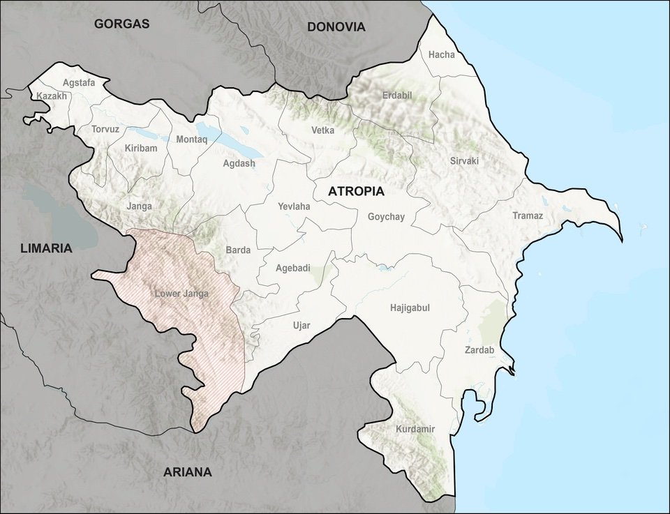
In this world, Atropia occupies the same territory that, in real geography, belongs to Azerbaijan. Its shape on U.S. Army maps follows the outline of Azerbaijan’s borders almost exactly – including its exclave, meant to represent Nakhchivan.
Even the name Atropia is no coincidence. It echoes Atropatene, an ancient kingdom that once existed in the territory of modern Azerbaijan and northwestern Iran. Through that historical reference, American planners gave their fictional state a layer of authenticity – and a faint trace of cultural memory.
Born in the Mojave Desert
The U.S. Army built Atropia first as a physical environment, not a digital one.
In the Mojave Desert, at the Fort Irwin National Training Center, twelve mock villages were constructed to represent Atropian towns and military zones. The design included local markets, mosques, industrial areas, and even government buildings – all meant to immerse U.S. troops in the social and cultural complexities of a South Caucasus–like region.
Every year, thousands of American soldiers rotate through Fort Irwin, learning how to interact with “Atropian civilians,” engage in hybrid warfare, negotiate with “local officials,” and respond to disinformation campaigns – all under the watchful eye of military evaluators.
A short film titled Atropia was later produced, using footage from the training grounds to illustrate the realism of this artificial state.
The scenario has since expanded to other U.S. military installations, including Fort Polk (Louisiana) and Fort Bragg (North Carolina). It also lives in cyberspace, integrated into computer-based exercises and digital wargames distributed under a Creative Commons license – meaning civilian researchers and universities can study or modify it.
Politics: A Pro-Western Autocracy
According to the official DATE documents, Atropia is a “neutral, Western-leaning oligarchy.”
Its government maintains a fragile alliance with the United States and NATO, but it operates as an authoritarian regime with limited political freedoms. Corruption is described as “widespread and systemic,” while the leadership clings to power through a network of loyal elites.
This model – a resource-rich state balancing between Western and regional powers – mirrors the geopolitical reality faced by many post-Soviet nations, especially Azerbaijan.
In training exercises, U.S. forces are often tasked with supporting Atropia’s government against internal unrest or foreign interference from Donovia, the Russian analogue.
The scenario challenges soldiers not just to fight, but to navigate diplomacy, information warfare, and humanitarian crises – the kinds of conflicts that dominate the modern geopolitical landscape.
Energy, Pipelines, and Power
Atropia’s fictional economy is built on oil and natural gas, its pipelines cutting across the continent toward Europe.
That detail, too, aligns neatly with reality: Azerbaijan’s own energy infrastructure – including the Baku–Tbilisi–Ceyhan pipeline – has long been a cornerstone of Eurasia’s strategic balance.
In the Atropia storyline, this energy wealth brings both prosperity and peril. The country’s natural resources attract investment from Western companies but also fuel corruption and make it a target for neighboring Donovia.
American troops deployed in the simulation must often protect “critical infrastructure” – a thinly veiled reference to the kind of security arrangements that might accompany real-world energy routes across the Caspian region.
A Laboratory for Modern Warfare
Atropia’s role in the DATE system goes beyond geography. It serves as a testing ground for the doctrines of modern conflict – information warfare, cyber operations, counterinsurgency, and civil-military cooperation.
Soldiers training there must deal with fabricated news stories, staged protests, and non-governmental organizations that may or may not be foreign agents. Every interaction is designed to blur the line between combat and politics — just as it would be in a real conflict zone like the South Caucasus.
As one U.S. defense analyst put it, “Atropia exists so the military can make mistakes in a world that doesn’t exist — before they make them in one that does.”
Cultural Resonance and Strategic Neutrality
For the U.S. military, the advantage of using fictional settings like Atropia is twofold:
it avoids diplomatic tensions with real nations, while preserving enough realism to make the training relevant.
This approach allows planners to simulate alliances, sanctions, and military interventions without ever naming Azerbaijan or Russia. It also enables allied forces – from Europe, Asia, or the Middle East – to train together in a shared, politically neutral context.
However, observers in the region have long noticed how closely Atropia’s characteristics align with Azerbaijan’s – from its Caspian coastline to its multi-vector foreign policy and strategic geography between Russia, Iran, and Turkey.
Even the DATE maps display neighboring states arranged precisely as on a real map of the Caucasus, with Donovia to the north and Ariana to the south.
Between Fiction and Forecast
The creation of Atropia reflects a broader trend in U.S. defense planning – the effort to simulate the world’s geopolitical flashpoints before they ignite.
By building “sandbox nations” like Atropia, Pentagon strategists can model how small, resource-rich countries navigate pressure from great powers.
For military scholars, this also underscores how seriously Washington takes the Caucasus as a potential theater of global competition.
In recent years, the region’s importance has only grown, as new trade corridors, pipelines, and post-war reconstruction efforts redraw the economic map between Europe and Asia.
A Real Lesson in a Fictional State
Behind its fictional borders, Atropia encapsulates the dilemmas of a real-world country:
how to remain independent amid rival empires, how to use natural wealth for stability, and how to balance alliances without losing sovereignty.
That is why, in the U.S. Army’s sprawling simulations, Atropia is more than a name – it is a mirror.
A reflection of how global powers view the South Caucasus: strategically vital, politically fragile, and permanently caught between East and West.
As one former Pentagon planner told Azerbaijan.US, “Atropia isn’t a fantasy. It’s a warning label – a reminder that geography is destiny, even in a simulation.”